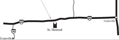
Saint Meinrad Archabbey is located in St. Meinrad, Indiana, 65 miles west of Louisville, Kentucky, and 55 miles east of Evansville, Indiana.
Online Map or GPS Directions
To find Saint Meinrad using a GPS or online mapping software, use this address:
Saint Meinrad Archabbey
200 Hill Drive
St. Meinrad, IN 47577
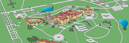
Pinpoint GPS Locations On Campus
-
Guest House Parking Lot: 38.166902, -86.813312
-
Mail Room door / Kitchen Driveway: 38.165370, -86.810100
-
Health Service: 38.166023, -86.810448
-
Physical Facilities Office: 38.161477, -86.808443
-
Books & Gifts: 38.164965, -86.810906
-
Abbey Caskets: 38.161496, -86.805080
Driving Directions
From the West
-
Take Interstate 64 east to Exit 63 (Ferdinand/Santa Claus);
-
Proceed south 2.5 miles on Indiana 162 to flashing red light;
-
Turn left on Indiana 62 and proceed 4 miles to Saint Meinrad.
From the East
-
Take Interstate 64 west to Exit 72 (Birdseye/Bristow);
-
Proceed south one block to Indiana 62;
-
Turn right and proceed 8 miles to Saint Meinrad.
From the North or South
-
Take U.S. 231 to Dale, IN.
-
Turn east onto Indiana 62 and drive 10 miles.
By Air
St. Meinrad, IN, is served by two airports, Louisville (KY) International Airport and Evansville (IN) Regional Airport.